I experienced my first magnitude 7.0-7.5 earthquake when I was 22 months old. It almost knocked me to the ground. That 1946 Vancouver Island earthquake struck Vancouver Island on June 23, 1946 at 10:15 a.m. with a magnitude estimated at 7.0 Ms and 7.5 Mw. The main shock epicenter occurred in the Forbidden Plateau area northwest of Courtenay. While most of the large earthquakes in the Vancouver area occur at tectonic plate boundaries, the 1946 Vancouver Island earthquake was a crustal event. Shaking was felt from Portland, Oregon, to Prince Rupert, British Columbia. There were a whole series of landslides in the Forbidden Plateau area that blocked streams and rivers to create lakes. The first hikers into the area gave them great names, Landslide Lake, Rock Fall Lake, Earthquake Lake etc.; over time these natural dams were eroded to nothing, leaving nothing but fading memories of those lakes. This earthquake is Canada's largest historic onshore earthquake. Canada has only been around for 155 years
Three years later, an earthquake, an M8.1, struck at 8:01 p.m. PDT on August 2, 1949 in Haida Gwaii [formerly Queen Charlotte Islands], an interplate earthquake that occurred on the ocean bottom just off the west coast of the main south island. The shock had a surface wave magnitude of 8.1 and a maximum Mercalli Intensity of VIII (Severe).
Countdown to Earthquake Drill - International Great ShakeOut Day is on Thursday, October 20, 2022 at 10:20AM, and annually on the 3rd Thursday in October thereafter - -
I grew up in small towns and in the North where the rule is share and share alike. So, I'm a Creative Commons type of guy. Copy and paste ANY OF MY MATERIAL anywhere you want. Hyperlinks to your own Social Media are at the bottom of each post. This work is licensed under my Creative Commons Attribution 4.0 International License.
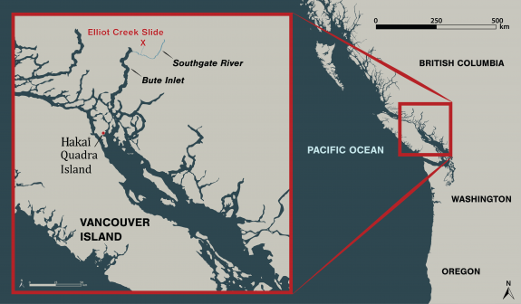
In the early morning hours of November 28, 2020, a chunk of mountain broke free and slid into a glacial lake in a remote part of the British Columbia coast 110 kilometers northeast of Campbell River. The amount of rock that fell into the lake could fill BC Place stadium five times, and triggered a 100-meter-high tsunami that ripped through Elliot Creek.
The landslide and video clips of the resulting destruction made headlines in numerous news outlets. While video snippets gave some sense of the scene, our Hakai Institute team filmed the entire 50-minute helicopter flight along what’s left of Elliot Creek, up to the lake and glacier, and back down to where Elliot Creek meets the Southgate River that flows into Bute Inlet. A map in the bottom left references the location of the helicopter during the corresponding video.
This video from December 17 represents an early snapshot of the emerging story of the massive landslide, its causes, and its fallout. The consequences of the landslide will take time to untangle, but initial concerns have concentrated on the impacts on Elliot Creek and the Southgate River as a salmon-bearing waterways, as well as how the event affected ocean conditions in Bute Inlet.
The landslide occurred on the traditional territory of the Homalco First Nation, and we are working closely with them and other partners to understand this event.
Stay tuned for much more news and science to follow as we analyze the consequences of this enormous event.
Videography by Grant Callegari and Katrina PyneEdited by Grant Callegari Video inset map by Will McInnes and Taylor Denouden Scientific measurements by Isabelle Desmarais Piloting by Tyler Bullick, West Coast Helicopters