I experienced my first magnitude 7.0-7.5 earthquake when I was 22 months old. It almost knocked me to the ground. That 1946 Vancouver Island earthquake struck Vancouver Island on June 23, 1946 at 10:15 a.m. with a magnitude estimated at 7.0 Ms and 7.5 Mw. The main shock epicenter occurred in the Forbidden Plateau area northwest of Courtenay. While most of the large earthquakes in the Vancouver area occur at tectonic plate boundaries, the 1946 Vancouver Island earthquake was a crustal event. Shaking was felt from Portland, Oregon, to Prince Rupert, British Columbia. There were a whole series of landslides in the Forbidden Plateau area that blocked streams and rivers to create lakes. The first hikers into the area gave them great names, Landslide Lake, Rock Fall Lake, Earthquake Lake etc.; over time these natural dams were eroded to nothing, leaving nothing but fading memories of those lakes. This earthquake is Canada's largest historic onshore earthquake. Canada has only been around for 155 years
Three years later, an earthquake, an M8.1, struck at 8:01 p.m. PDT on August 2, 1949 in Haida Gwaii [formerly Queen Charlotte Islands], an interplate earthquake that occurred on the ocean bottom just off the west coast of the main south island. The shock had a surface wave magnitude of 8.1 and a maximum Mercalli Intensity of VIII (Severe).
Countdown to Earthquake Drill - International Great ShakeOut Day is on Thursday, October 20, 2022 at 10:20AM, and annually on the 3rd Thursday in October thereafter - -
I grew up in small towns and in the North where the rule is share and share alike. So, I'm a Creative Commons type of guy. Copy and paste ANY OF MY MATERIAL anywhere you want. Hyperlinks to your own Social Media are at the bottom of each post. This work is licensed under my Creative Commons Attribution 4.0 International License.
19,291
views • Apr 8, 2021 • Within Canada is a volcano that relatively
recently produced an eruption comparable in size to the 1980 eruption
of Mount Saint Helens. The volcano in question is known as Mount
Meager, which is still relatively active today as evidenced by its
hot springs and fumaroles. This video covers the recent eruptions
from this volcano, including its 410 BC Eruption, and states the
general hazard which it poses in the future. This video was made by a
geologist who is based in Arizona. If you would like to support this
channel, consider becoming a patron at http://patreon.com/geologyhub.
Another way to support this channel is to make an order via our
gemstone and geology related etsy store at
http://prospectingarizona.etsy.com.
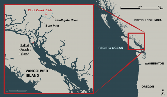
In the early morning hours of November 28, 2020, a chunk of mountain broke free and slid into a glacial lake in a remote part of the British Columbia coast 110 kilometers northeast of Campbell River. The amount of rock that fell into the lake could fill BC Place stadium five times, and triggered a 100-meter-high tsunami that ripped through Elliot Creek.
The landslide and video clips of the resulting destruction made headlines in numerous news outlets. While video snippets gave some sense of the scene, our Hakai Institute team filmed the entire 50-minute helicopter flight along what’s left of Elliot Creek, up to the lake and glacier, and back down to where Elliot Creek meets the Southgate River that flows into Bute Inlet. A map in the bottom left references the location of the helicopter during the corresponding video.
This video from December 17 represents an early snapshot of the emerging story of the massive landslide, its causes, and its fallout. The consequences of the landslide will take time to untangle, but initial concerns have concentrated on the impacts on Elliot Creek and the Southgate River as a salmon-bearing waterways, as well as how the event affected ocean conditions in Bute Inlet.
The landslide occurred on the traditional territory of the Homalco First Nation, and we are working closely with them and other partners to understand this event.
Stay tuned for much more news and science to follow as we analyze the consequences of this enormous event.
Videography by Grant Callegari and Katrina PyneEdited by Grant Callegari Video inset map by Will McInnes and Taylor Denouden Scientific measurements by Isabelle Desmarais Piloting by Tyler Bullick, West Coast Helicopters
You would think that scientists would follow scientific methods; not jump to irrational, UNSCIENTIFIC spectacular conclusions ~ a cause célèbre from some reality TV show whose fame will not even lasted the proverbial 15 minutes? Everything, but everything today is blamed on human caused Climate change?, balderdash. Does that make sense to anyone, at all.
Scientists
at Simon Fraser University argue that climate change is destabilizing
volcanoes around the world, and they're using a British Columbia
mountain range to prove their theory. Not far from Whistler, Mount
Meager shows signs of dangerous things to come, which has researchers
keeping a very close eye on it. Welcome to The National, the flagship
nightly newscast of CBC News »»» Subscribe to The National to
watch more videos here: https://www.youtube.com/user/CBCTheNa...
Voice Your Opinion & Connect With Us Online: The National Updates
on Facebook: https://www.facebook.com/thenational
The National Updates on Twitter: https://twitter.com/CBCTheNational
»»» »»» »»» »»» »»» The National is CBC Television's
flagship news program. Airing six days a week, the show delivers
news, feature documentaries and analysis from some of Canada's
leading journalists.
On August 6, 2010 a massive
lahar cascaded down from Capricorn Glacier at a speed of 30 m (98 ft)
per second. Experts initially estimated that the volume of debris
totaled 40,000,000 m3++ [cubic metres] = (1.4×10⁹++ cu ft) which would make it the largest landslide on record in Canadian history. The record was previously held by the 1965 Hope
Slide that removed 47,000,000 m3 (1.7×10⁹ cu ft) of rock from Johnson
Peak. However the Meager landslide was later estimated to be more than
48,500,000 m3 (1.71×10⁹ cu ft), making it the largest landslide in Canada's short 155 year history. [Canada became a country on July 1, 1867]. The firstseismograph (one of the first in the world) was built in Victoria in 1898, recording its first earthquake eight days later. This seismograph was operated by Francis Denison of the Meteorological Service of Canada, who recorded and described the M 7 earthquake on December 6, 1918 on the west coast of Vancouver Island.
The 2010 landslide at Mount Meager was 300
m (980 ft) wide and 2 km (1.2 mi) long, creating a dam across Meager
Creek and the Lillooet River. This resulted in the creation of a lake
just upstream. Early concerns that the dam might collapse and flood the
Lillooet River valley ended a day later, when part of the dam ruptured
and slowly released the accumulated water. An evacuation alert was
rescinded, and nearly 1,500 residents were allowed to return to their
homes on the weekend after the landslide occurred. No injuries were
reported.
2010-08-12 · It was pitch-black when a roar and rumble rocked Mt. Meager. These are the unmistakable signs of disaster in a region classified slide-prone. When word of a landslide reached Pemberton, some 70...
The 2010 Mount Meager landslide was a large catastrophic debris avalanche that occurred in southwestern British Columbia, Canada, on August 6 at 3:27 a.m. PDT (UTC-7). More than 45,000,000 m (1.6×10 cu ft) of debris slid down Mount Meager, temporarily blocking Meager Creek and destroying local bridges, roads and equipment. It was one of the largest landslides in Canadian history and one of over 20 landslides to have occurred from the Mount Meager massif in the last 10,000 years.
2020-03-04 · Mount Meager landslide risk. Picture: CBC. Mount Meader ice splits apart. The ice covering the sleeping volcano is splitting apart, revealing the bottom of the glacier about 30 to 40 meters (98 to 131 feet) below as if someone took a laser and melted the middle of the glacier. The three fumaroles feature the increasing instability of the volcano and the need for 24-hour monitoring and alarm ...
2011-08-04 · The site of last year's Mount Meager landslide is seen here on Friday (July 30). The area remains scarred from the massive rock avalanche that is now considered the largest on record in Canadian history. Photo by Photo by Dave Steers / www.wpnn.org Patrick Smith won't likely ever forget the early morning hours of Aug. 6, 2010.
The Meager landslide was caused by a massive collapse of Mount Meager's south flank. All post-collapse pictures were provided by Dave Steers, a member of the Pemberton Search and Rescue team. (Mount Meager South Flank Collapse Causes Second Largest Landslide in Canadian History)
The
Mount
Meager massif
is a group of volcanic peaks in the Pacific
Ranges
of the Coast
Mountains
in southwestern British
Columbia,
Canada. Part of the Cascade
Volcanic Arc
of western North America, it is located 150 km (93 mi) north of
Vancouver
at the northern end of the Pemberton
Valley
and reaches a maximum elevation of 2,680 m (8,790 ft). The massif is
capped by several eroded volcanic edifices, including lava
domes,
volcanic
plugs
and overlapping piles of lava flows; these form at least six major
summits
including Mount Meager which is the second highest of the massif.
The
Garibaldi
Volcanic Belt
(GVB) has a long history of eruptions and poses a threat to the
surrounding region. Any volcanic
hazard
ranging from landslides
to eruptions could pose a significant risk to humans and wildlife.
Although the massif has not erupted for more than 2,000 years, it
could produce a major eruption; if this were to happen, relief
efforts would be quickly organized. Teams such as the Interagency
Volcanic Event Notification Plan
(IVENP) are prepared to notify people threatened by volcanic
eruptions in Canada.
The
Mount Meager massif produced the largest volcanic eruption in Canada
in the last 10,000 years. About 2,400 years ago, an explosive
eruption
formed a volcanic
crater
on its northeastern flank and sent avalanches of hot ash, rock
fragments and volcanic
gases
down the northern flank of the volcano. Evidence for more recent
volcanic activity has been documented at the volcano, such as hot
springs
and earthquakes.
The Mount Meager massif has also been the source of several large
landslides in the past, including a massive debris
flow
in 2010 that swept down Meager
Creek
and the Lillooet River.