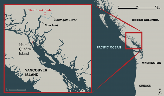
In the early morning hours of November 28, 2020, a chunk of mountain broke free and slid into a glacial lake in a remote part of the British Columbia coast 110 kilometers northeast of Campbell River. The amount of rock that fell into the lake could fill BC Place stadium five times, and triggered a 100-meter-high tsunami that ripped through Elliot Creek.
The landslide and video clips of the resulting destruction made headlines in numerous news outlets. While video snippets gave some sense of the scene, our Hakai Institute team filmed the entire 50-minute helicopter flight along what’s left of Elliot Creek, up to the lake and glacier, and back down to where Elliot Creek meets the Southgate River that flows into Bute Inlet. A map in the bottom left references the location of the helicopter during the corresponding video.
This video from December 17 represents an early snapshot of the emerging story of the massive landslide, its causes, and its fallout. The consequences of the landslide will take time to untangle, but initial concerns have concentrated on the impacts on Elliot Creek and the Southgate River as a salmon-bearing waterways, as well as how the event affected ocean conditions in Bute Inlet.
The landslide occurred on the traditional territory of the Homalco First Nation, and we are working closely with them and other partners to understand this event.
Stay tuned for much more news and science to follow as we analyze the consequences of this enormous event.
Videography by Grant Callegari and Katrina PyneEdited by Grant Callegari Video inset map by Will McInnes and Taylor Denouden Scientific measurements by Isabelle Desmarais Piloting by Tyler Bullick, West Coast Helicopters
You would think that scientists would follow scientific methods; not jump to irrational, UNSCIENTIFIC spectacular conclusions ~ a cause célèbre from some reality TV show whose fame will not even lasted the proverbial 15 minutes? Everything, but everything today is blamed on human caused Climate change?, balderdash. Does that make sense to anyone, at all.
Scientists
at Simon Fraser University argue that climate change is destabilizing
volcanoes around the world, and they're using a British Columbia
mountain range to prove their theory. Not far from Whistler, Mount
Meager shows signs of dangerous things to come, which has researchers
keeping a very close eye on it. Welcome to The National, the flagship
nightly newscast of CBC News »»» Subscribe to The National to
watch more videos here: https://www.youtube.com/user/CBCTheNa...
Voice Your Opinion & Connect With Us Online: The National Updates
on Facebook: https://www.facebook.com/thenational
The National Updates on Twitter: https://twitter.com/CBCTheNational
»»» »»» »»» »»» »»» The National is CBC Television's
flagship news program. Airing six days a week, the show delivers
news, feature documentaries and analysis from some of Canada's
leading journalists.